Snow could fall very heavily, up to 1 to 2 inches per hour, much of it overnight.
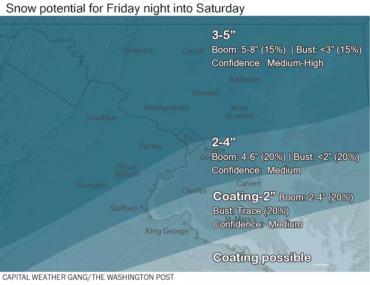
We have increasingly high confidence in a quick-hitting, accumulating snow arriving Friday evening and winding down by early Saturday before sunrise. The overnight timing and likelihood of a few-hour period of moderate to heavy snow means that roads should become snow-covered and hazardous, even though temperatures will start out above freezing. However, any travel disruptions should ease by mid-to-late Saturday morning.is posted for Frederick and western Loudoun counties and points west.
We’re forecasting 2 to 4 inches around downtown D.C. and to the south and east, except only a coating to 2 inches in Southern Maryland. In these zones, precipitation could start as rain or a rain-snow mix, and slightly warmer temperatures should keep accumulations down a bit.Snow arrives from west to east, possibly starting as rain or a rain-snow mix around downtown Washington and to the south and east, and becoming moderate to heavy to the west. Temperatures: Mid-to-upper 30s.
Temperatures described above will be lowest in areas north and west of downtown Washington and highest to the south and east.The storm only rates as a low-end Category 2 out of 5 on our. It’s essentially occurring at one of the least disruptive times possible — in the middle of the night before a long weekend. And, outside a lingering snow shower or two, it will be over by the time most people are waking up.
If you’re among the few to be on the roads between midnight and 5 a.m. Saturday, however, driving will be very hazardous because of the snowfall rates of 1 to 2 inches per hour and low visibilities. Roads will quickly become snow-covered and slick. Yes, it’s probable that if you have Saturday morning plans, they may be disrupted until crews can treat and plow neighborhood roads, assuming you don’t feel comfortable driving on a bit of snow. We imagine major roads will be cleared pretty quickly Saturday morning. There could be delays and some cancellations at airports, so check your flight status before heading out.By Saturday afternoon, snow will be steadily melting, and the area should be able to return to normal pretty fast.
Österreich Neuesten Nachrichten, Österreich Schlagzeilen
Similar News:Sie können auch ähnliche Nachrichten wie diese lesen, die wir aus anderen Nachrichtenquellen gesammelt haben.
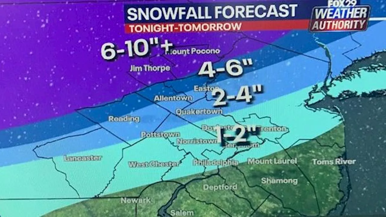 Philadelphia snow forecast: Winter storm alerts with snow on the way Monday nightParts of the Delaware Valley are bracing for a winter storm that forecasters believe will dump measurable snow in parts of the region overnight Monday into Tuesday.
Weiterlesen »
 More snow for the Denver metro area Friday nightLisa provides the latest First Alert Weather forecast on Denver7 starting at 4:30am every weekday morning.
Weiterlesen »
 Warmer weather brings chance of rain-snow mix to Anchorage starting Friday nightA foot of snow and 90 mph wind gusts early Friday pushed avalanche danger to high in Turnagain Pass.
Weiterlesen »
 Philadelphia snow forecast: Overnight winter storm to dump measurable snow across Delaware ValleyAnother winter storm will impact the Delaware Valley overnight, bringing measurable snowfall totals across the region.
Weiterlesen »
 Mayor Bowser to Deploy District Snow Team in Anticipation of SnowMayor Muriel Bowser will deploy the District Snow Team in anticipation of snow predicted to begin Friday evening. Pre-treatment brine operations will also begin on snow emergency routes. The National Weather Service is forecasting about two inches of snow with slushy conditions expected.
Weiterlesen »
 Snow totals: Here's how much snow fell in Pennsylvania, New Jersey on TuesdayA quick-hitting winter storm rolled across the Delaware Valley on Tuesday morning, dumping plowable snow in places across the region.
Weiterlesen »